
Thank you for supporting this site ❤️
Make a donation
Make a donation
Les Friats topographic map
Click on the map to display elevation.
Thank you for supporting this site ❤️
Make a donation
Make a donation
About this map
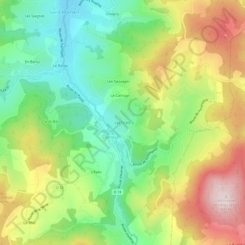
Name: Les Friats topographic map, elevation, terrain.
Average elevation: 583 m
Minimum elevation: 397 m
Maximum elevation: 840 m
Thank you for supporting this site ❤️
Make a donation
Make a donation
Other topographic maps
Click on a map to view its topography, its elevation and its terrain.
La Grosne Orientale
France > Auvergne-Rhône-Alpes > Rhône > Deux-Grosnes > Ouroux
Average elevation: 568 m