
Thank you for supporting this site ❤️
Make a donation
Make a donation
Wise County topographic map
Click on the map to display elevation.
Thank you for supporting this site ❤️
Make a donation
Make a donation
About this map
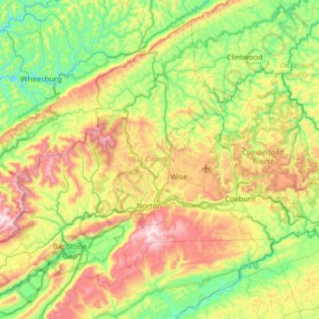
Name: Wise County topographic map, elevation, terrain.
Location: Wise County, Virginia, United States (36.79899 -82.87858 37.20281 -82.29856)
Average elevation: 647 m
Minimum elevation: 330 m
Maximum elevation: 1,263 m
Thank you for supporting this site ❤️
Make a donation
Make a donation
Other topographic maps
Click on a map to view its topography, its elevation and its terrain.