
City of Zagreb topographic map
Interactive map
Click on the map to display elevation.
About this map
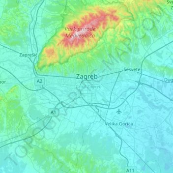
Name: City of Zagreb topographic map, elevation, terrain.
Location: City of Zagreb, Croatia (45.61421 15.77361 45.96915 16.24060)
Average elevation: 182 m
Minimum elevation: 95 m
Maximum elevation: 1,027 m
Other topographic maps
Click on a map to view its topography, its elevation and its terrain.
Ika
Croatia > Primorje-Gorski Kotar County > Grad Opatija
Ika, Grad Opatija, Primorje-Gorski Kotar County, 51415, Croatia
Average elevation: 143 m
Imotski
Croatia > Split-Dalmatia County
Imotski, Grad Imotski, Split-Dalmatia County, 21260, Croatia
Average elevation: 394 m
Donja Pušća
Donja Pušća, Općina Pušća, Zagreb County, 10294, Croatia
Average elevation: 187 m