
Thank you for supporting this site ❤️
Make a donation
Make a donation
Blenheim topographic map
Click on the map to display elevation.
Thank you for supporting this site ❤️
Make a donation
Make a donation
About this map
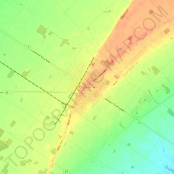
Name: Blenheim topographic map, elevation, terrain.
Location: Blenheim, Chatham-Kent, Ontario, N0P 2A0, Canada (42.29542 -82.03741 42.37542 -81.95741)
Average elevation: 198 m
Minimum elevation: 175 m
Maximum elevation: 220 m
Thank you for supporting this site ❤️
Make a donation
Make a donation
Other topographic maps
Click on a map to view its topography, its elevation and its terrain.