
Thank you for supporting this site ❤️
Make a donation
Make a donation
Saadiyat Island topographic map
Click on the map to display elevation.
Thank you for supporting this site ❤️
Make a donation
Make a donation
About this map
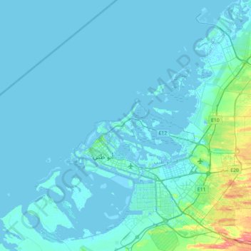
Name: Saadiyat Island topographic map, elevation, terrain.
Location: Saadiyat Island, Abu Dhabi, United Arab Emirates (24.21032 54.12091 24.85032 54.76091)
Average elevation: 6 m
Minimum elevation: -9 m
Maximum elevation: 94 m
Thank you for supporting this site ❤️
Make a donation
Make a donation