Jere topographic map
Interactive map
Click on the map to display elevation.
About this map
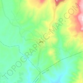
Name: Jere topographic map, elevation, terrain.
Location: Jere, East Wellega, Oromia Region, Ethiopia (9.17671 37.02789 9.25671 37.10789)
Average elevation: 1,957 m
Minimum elevation: 1,738 m
Maximum elevation: 2,450 m
Other topographic maps
Click on a map to view its topography, its elevation and its terrain.
Mojo
Mojo (Oromo: Moojoo, Amharic: ሞጆ) is a town in central Ethiopia, named after the nearby Modjo River. Located in the East Shewa Zone of the Oromia Region, it has a latitude and longitude of 8°39′N 39°5′E / 8.650°N 39.083°E / 8.650; 39.083 with an elevation between 1788 and 1825 meters above…
Average elevation: 1,800 m