
Thank you for supporting this site ❤️
Make a donation
Make a donation
Montville topographic map
Click on the map to display elevation.
Thank you for supporting this site ❤️
Make a donation
Make a donation
About this map
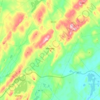
Name: Montville topographic map, elevation, terrain.
Location: Montville, Waldo County, Maine, United States (44.36466 -69.35744 44.52268 -69.20344)
Average elevation: 152 m
Minimum elevation: 49 m
Maximum elevation: 338 m
Thank you for supporting this site ❤️
Make a donation
Make a donation
Other topographic maps
Click on a map to view its topography, its elevation and its terrain.