
Thank you for supporting this site ❤️
Make a donation
Make a donation
Barrio "KENNEDY" topographic map
Click on the map to display elevation.
Thank you for supporting this site ❤️
Make a donation
Make a donation
About this map
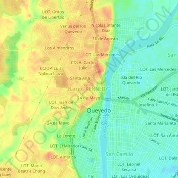
Name: Barrio "KENNEDY" topographic map, elevation, terrain.
Location: Barrio "KENNEDY", Quevedo, Los Ríos, 120302, Ecuador (-1.03963 -79.48853 -0.99963 -79.44853)
Average elevation: 65 m
Minimum elevation: 43 m
Maximum elevation: 89 m
Thank you for supporting this site ❤️
Make a donation
Make a donation
Other topographic maps
Click on a map to view its topography, its elevation and its terrain.
Área Verde en Ladera
Ecuador > Los Ríos > Quevedo > Quevedo > LOT. KARINA Mz. "B"
Average elevation: 65 m