
Thank you for supporting this site ❤️
Make a donation
Make a donation
Endeavour topographic map
Click on the map to display elevation.
Thank you for supporting this site ❤️
Make a donation
Make a donation
About this map
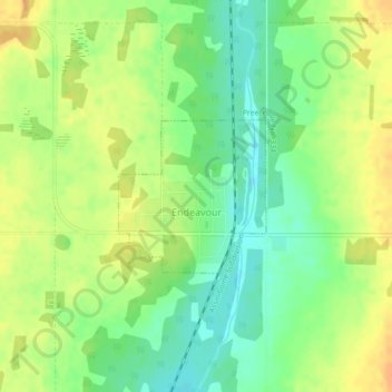
Name: Endeavour topographic map, elevation, terrain.
Location: Endeavour, Division No. 9, Saskatchewan, Canada (52.15552 -102.66535 52.16611 -102.64876)
Average elevation: 534 m
Minimum elevation: 517 m
Maximum elevation: 549 m
Thank you for supporting this site ❤️
Make a donation
Make a donation
Other topographic maps
Click on a map to view its topography, its elevation and its terrain.