
Make a donation
Erie County topographic map
Click on the map to display elevation.
Make a donation
Erie County
The northern border of the county is Tonawanda Creek. Part of the southern border is Cattaraugus Creek. Other major streams include Buffalo Creek (Buffalo River), Cayuga Creek, Cazenovia Creek, Scajaquada Creek, Eighteen Mile Creek and Ellicott Creek. The county's northern half, including Buffalo and its suburbs, is known as the Northtowns and is relatively flat and rises gently up from the lake. The southern half, known as the Southtowns, is much hillier. It has the northwesternmost foothills of the Appalachian Mountains. The highest elevation in the county is a hill in the Town of Sardinia that tops out at around 1,940 feet (591 m) above sea level. The lowest ground is about 560 feet (171 m), on Grand Island at the Niagara River. The Onondaga Escarpment runs through the northern part of Erie County.
Make a donation
About this map
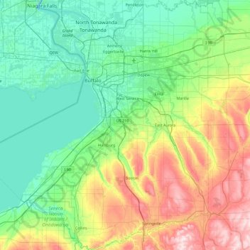
Name: Erie County topographic map, elevation, terrain.
Location: Erie County, New York, United States (42.43800 -79.29797 43.09870 -78.46174)
Average elevation: 286 m
Minimum elevation: 99 m
Maximum elevation: 649 m
Make a donation
Other topographic maps
Click on a map to view its topography, its elevation and its terrain.
Central Park
United States > New York > New York County > New York
In June 1856, Fernando Wood appointed a "consulting board" of seven people, headed by author Washington Irving, to inspire public confidence in the proposed development. Wood hired military engineer Egbert Ludovicus Viele as the park's chief engineer, tasking him with a topographical survey of the site. The…
Average elevation: 26 m
Brooklyn Bridge Park
United States > New York > Kings County > New York
Brooklyn Bridge Park spans 85 acres (34 ha) of the East River waterfront in the Brooklyn Heights and Dumbo neighborhoods of Brooklyn. The park is divided into eleven sections: Piers 1 through 6; Fulton Ferry Landing; Brooklyn Bridge Plaza; Empire Fulton Ferry; Main Street; and John Street. Each of these…
Average elevation: 9 m
Make a donation
Mount Marcy
United States > New York > Essex County > Town of Keene
Mount Marcy is the highest point in the Adirondack Mountains and the U.S. state of New York, with an elevation of 5,343.1 feet (1,628.6 m). It is located in the town of Keene in Essex County. The mountain is in the heart of the High Peaks Wilderness Area in Adirondack Park. Like the surrounding Adirondack…
Average elevation: 1,289 m
Catskill mountains view
United States > New York > Greene County > Town of Hunter
Average elevation: 740 m
Make a donation
Inwood Hill Park
United States > New York > New York County > New York
Inwood Hill Park is a 196 acres (79 ha) public park in the Inwood neighborhood of Manhattan, New York City, operated by the New York City Department of Parks and Recreation. On a high schist ridge that rises 200 feet (61 m) above the Hudson River from Dyckman Street to the northern tip of the island, Inwood…
Average elevation: 14 m
Make a donation
Make a donation
East Poestenkill
United States > New York > Rensselaer County > Town of Poestenkill
Average elevation: 376 m
Make a donation
Chenango Lake
United States > New York > Chenango County > Town of New Berlin
Average elevation: 513 m
Make a donation
Tusten Mountain Lake
United States > New York > Sullivan County > Town of Tusten
Average elevation: 346 m
North Germantown
United States > New York > Columbia County > Town of Germantown
Average elevation: 34 m
Make a donation
Hoopers Valley Island
United States > New York > Tioga County > Hoopers Valley
Average elevation: 267 m
Tug Hill
United States > New York > Oswego County
The core Tug Hill region encompasses 150,000 acres (610 km2) of unbroken, generally second-growth, northern hardwood forest, and is drained by a vast network of streams. Important rivers and streams whose headwaters are located within the Tug Hill region include the Mohawk River, Deer River, Salmon River, Mad…
Average elevation: 109 m
South Salem
United States > New York > Westchester County > Town of Lewisboro
Average elevation: 174 m
Make a donation
Barberville
United States > New York > Rensselaer County > Town of Poestenkill
Average elevation: 269 m
Make a donation
Make a donation
Make a donation
Big Bad Luck Pond
United States > New York > Hamilton County > Town of Indian Lake
Average elevation: 539 m
Make a donation
Woodcock Mountain
United States > New York > Saratoga County > Town of Hadley
Average elevation: 271 m
Constantia Center
United States > New York > Oswego County > Town of Constantia
Average elevation: 169 m
South New Berlin
United States > New York > Chenango County > Town of New Berlin
Average elevation: 380 m
Make a donation
Coney Island
United States > New York > Saint Lawrence County > Town of Pierrepont
Average elevation: 174 m
Make a donation
Make a donation
Make a donation
Make a donation
Sunset Ridge
United States > New York > Westchester County > Town/Village of Harrison
Average elevation: 27 m
Make a donation
Make a donation
Ellicottville
United States > New York > Cattaraugus County > Village of Ellicottville
Average elevation: 573 m
Make a donation
Niagara Escarpment
United States > New York > Niagara County > City of Lockport
Average elevation: 149 m
Make a donation
Ellenburg Mountain
United States > New York > Clinton County > Town of Ellenburg
Average elevation: 682 m
Make a donation
Make a donation
Make a donation
Make a donation