
Cantabria topographic map
Interactive map
Click on the map to display elevation.
About this map
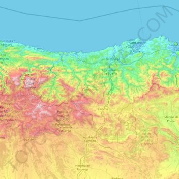
Name: Cantabria topographic map, elevation, terrain.
Location: Cantabria, Spain (42.75805 -4.85174 43.51362 -3.14965)
Average elevation: 643 m
Minimum elevation: -3 m
Maximum elevation: 2,593 m
Other topographic maps
Click on a map to view its topography, its elevation and its terrain.
Linares
Spain > Cantabria > Castro-Urdiales
Linares, Castro-Urdiales, Costa Oriental, Cantabria, 39798, Spain
Average elevation: 416 m
Picos de Europa
Picos de Europa, Cabaña Verónica-Urriellu, Cabrales, Liébana, Cantabria, Spain
Average elevation: 2,290 m