
Thank you for supporting this site ❤️
Make a donation
Make a donation
Höllental topographic map
Click on the map to display elevation.
Thank you for supporting this site ❤️
Make a donation
Make a donation
About this map
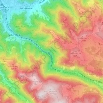
Name: Höllental topographic map, elevation, terrain.
Average elevation: 844 m
Minimum elevation: 433 m
Maximum elevation: 1,222 m
Thank you for supporting this site ❤️
Make a donation
Make a donation
Other topographic maps
Click on a map to view its topography, its elevation and its terrain.
Vorderdorf
Deutschland > Baden-Württemberg > Landkreis Breisgau-Hochschwarzwald > Breitnau
Average elevation: 992 m
79874
Deutschland > Baden-Württemberg > Landkreis Breisgau-Hochschwarzwald > Breitnau
Average elevation: 939 m
Oberhöllsteig
Deutschland > Baden-Württemberg > Landkreis Breisgau-Hochschwarzwald > Breitnau
Average elevation: 920 m