
Thank you for supporting this site ❤️
Make a donation
Make a donation
Moheda topographic map
Click on the map to display elevation.
Thank you for supporting this site ❤️
Make a donation
Make a donation
About this map
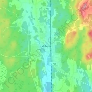
Name: Moheda topographic map, elevation, terrain.
Location: Moheda, Alvesta kommun, Kronoberg County, 342 60, Sweden (56.98436 14.55281 57.02436 14.59281)
Average elevation: 179 m
Minimum elevation: 146 m
Maximum elevation: 250 m
Thank you for supporting this site ❤️
Make a donation
Make a donation
Other topographic maps
Click on a map to view its topography, its elevation and its terrain.