
Make a donation
Wolzburg topographic map
Click on the map to display elevation.
Make a donation
About this map
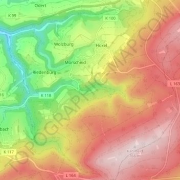
Name: Wolzburg topographic map, elevation, terrain.
Average elevation: 558 m
Minimum elevation: 318 m
Maximum elevation: 765 m
Make a donation
Other topographic maps
Click on a map to view its topography, its elevation and its terrain.
Riedenburg
Deutschland > Rheinland-Pfalz > Landkreis Bernkastel-Wittlich > Morbach
Average elevation: 470 m
Weiperath
Deutschland > Rheinland-Pfalz > Landkreis Bernkastel-Wittlich > Morbach
Average elevation: 439 m
Gonzerath
Deutschland > Rheinland-Pfalz > Landkreis Bernkastel-Wittlich > Morbach
Average elevation: 503 m
Wederath
Deutschland > Rheinland-Pfalz > Landkreis Bernkastel-Wittlich > Morbach
Average elevation: 524 m
Make a donation
Gutenthal
Deutschland > Rheinland-Pfalz > Landkreis Bernkastel-Wittlich > Morbach
Der Ort liegt südwestlich von Morbach an der Hunsrückhöhenstraße. Zu Gutenthal gehört auch der Wohnplatz Auf der Heide. Nachbarorte sind im Nordosten Morbach selbst, sowie die Gemeindeteile Hoxel und Wolzburg im Süden, Odert im Westen und Weiperath im Nordwesten.
Average elevation: 489 m
Kahlheid
Deutschland > Rheinland-Pfalz > Landkreis Bernkastel-Wittlich > Morbach
Average elevation: 681 m
Elzerath
Deutschland > Rheinland-Pfalz > Landkreis Bernkastel-Wittlich > Morbach > Elzerath
Average elevation: 505 m
Make a donation
Bischofsdhron
Deutschland > Rheinland-Pfalz > Landkreis Bernkastel-Wittlich > Morbach
Average elevation: 533 m