
Thank you for supporting this site ❤️
Make a donation
Make a donation
Zion Lodge topographic map
Click on the map to display elevation.
Thank you for supporting this site ❤️
Make a donation
Make a donation
About this map
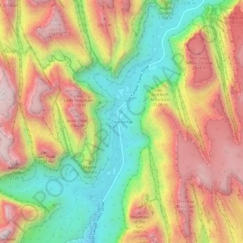
Name: Zion Lodge topographic map, elevation, terrain.
Location: Zion Lodge, Washington County, Utah, United States (37.22985 -112.97709 37.26985 -112.93709)
Average elevation: 1,722 m
Minimum elevation: 1,263 m
Maximum elevation: 2,176 m
Thank you for supporting this site ❤️
Make a donation
Make a donation
Other topographic maps
Click on a map to view its topography, its elevation and its terrain.
Thank you for supporting this site ❤️
Make a donation
Make a donation
Thank you for supporting this site ❤️
Make a donation
Make a donation