
Picard topographic map
Interactive map
Click on the map to display elevation.
About this map
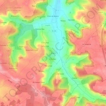
Name: Picard topographic map, elevation, terrain.
Average elevation: 168 m
Minimum elevation: 87 m
Maximum elevation: 225 m
Other topographic maps
Click on a map to view its topography, its elevation and its terrain.
Cambes
France > Nouvelle-Aquitaine > Lot-et-Garonne > Pujols
Cambes, Pujols, Villeneuve-sur-Lot, Lot-et-Garonne, Nouvelle-Aquitaine, France métropolitaine, 47300, France
Average elevation: 165 m
Barrèges
France > Nouvelle-Aquitaine > Lot-et-Garonne > Pujols > Barrèges
Barrèges, Pujols, Villeneuve-sur-Lot, Lot-et-Garonne, Nouvelle-Aquitaine, France métropolitaine, 47300, France
Average elevation: 145 m
Brulet
France > Nouvelle-Aquitaine > Lot-et-Garonne > Pujols
Brulet, Pujols, Villeneuve-sur-Lot, Lot-et-Garonne, Nouvelle-Aquitaine, France métropolitaine, 47300, France
Average elevation: 167 m
Sous Chays
France > Nouvelle-Aquitaine > Lot-et-Garonne > Pujols
Sous Chays, Pujols, Villeneuve-sur-Lot, Lot-et-Garonne, Nouvelle-Aquitaine, France métropolitaine, 47300, France
Average elevation: 102 m