
Thank you for supporting this site ❤️
Make a donation
Make a donation
Todenfeld topographic map
Click on the map to display elevation.
Thank you for supporting this site ❤️
Make a donation
Make a donation
Todenfeld
Der Ort liegt rund 6 km südlich der Rheinbacher Kernstadt an der L492 auf den Höhen der nördlichen Eifel im Ahrgebirge unmittelbar an der Landesgrenze zu Rheinland-Pfalz. Nachbarorte sind im Südosten Bad Neuenahr-Ahrweiler, Südwesten Bad Münstereifel, Nordwesten Euskirchen und Nordosten Meckenheim. Die nächstgelegenen Bahnhöfe sind Rheinbach und Meckenheim an der Bahnstrecke der Voreifelbahn Bonn-Euskirchen, und die nächste Autobahnanschlussstelle ist Rheinbach/ Meckenheim an der A 61.
Thank you for supporting this site ❤️
Make a donation
Make a donation
About this map
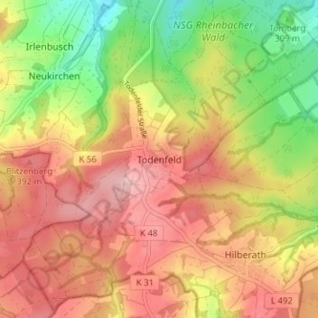
Name: Todenfeld topographic map, elevation, terrain.
Average elevation: 335 m
Minimum elevation: 238 m
Maximum elevation: 411 m
Thank you for supporting this site ❤️
Make a donation
Make a donation
Other topographic maps
Click on a map to view its topography, its elevation and its terrain.