
Make a donation
Jabal Shams topographic map
Click on the map to display elevation.
Make a donation
Jabal Shams
The mountain also has a second summit, the South Summit, which is publicly accessible for trekking via the W4 Trail, marked by the Oman Ministry of Tourism. The elevation of the second south summit is 2,997 m (9,833 ft).
Make a donation
About this map
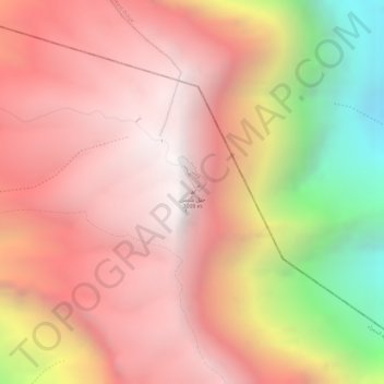
Name: Jabal Shams topographic map, elevation, terrain.
Average elevation: 2,451 m
Minimum elevation: 1,379 m
Maximum elevation: 2,985 m
Make a donation
Other topographic maps
Click on a map to view its topography, its elevation and its terrain.
Izki
Oman > Ad Dakhiliyah Governorate
Izki (Arabic: إِزْكِي) is a town in the Ad Dakhiliyah region of northeastern Oman. It is located at c. 544 m (1,785 ft) altitude, and has a population of 35,173 (2003 census).
Average elevation: 662 m
Bahla Fort
Oman > Ad Dakhiliyah Governorate > Bahla Province
Preservation attempt in 1995 was found to be a renovation not a restoration because the aim of the remodeling was to make the fort look new. This renovation began without prior archaeological, topographic, architectural or technical surveys.
Average elevation: 575 m
Make a donation