
Make a donation
Треска topographic map
Click on the map to display elevation.
Make a donation
About this map
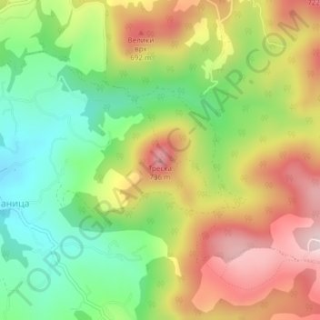
Name: Треска topographic map, elevation, terrain.
Average elevation: 532 m
Minimum elevation: 360 m
Maximum elevation: 734 m
Make a donation
Other topographic maps
Click on a map to view its topography, its elevation and its terrain.
Rudnik
Serbia > Moravica Administrative District > Gornji Milanovac Municipality
Average elevation: 596 m
Brdjani
Serbia > Moravica Administrative District > Gornji Milanovac Municipality
Average elevation: 355 m
Kriva Reka
Serbia > Moravica Administrative District > Gornji Milanovac Municipality
Average elevation: 348 m
Dragolj
Serbia > Moravica Administrative District > Gornji Milanovac Municipality
Average elevation: 301 m
Make a donation
Brusnica
Serbia > Moravica Administrative District > Gornji Milanovac Municipality
Average elevation: 401 m
Gornja Crnuca
Serbia > Moravica Administrative District > Gornji Milanovac Municipality
Average elevation: 625 m
Jablanica
Serbia > Moravica Administrative District > Gornji Milanovac Municipality
Average elevation: 521 m
Trudelj
Serbia > Moravica Administrative District > Gornji Milanovac Municipality
Average elevation: 390 m
Make a donation
Takovo
Serbia > Moravica Administrative District > Gornji Milanovac Municipality
Average elevation: 426 m
Kostunici
Serbia > Moravica Administrative District > Gornji Milanovac Municipality
Average elevation: 601 m
Donja Vrbava
Serbia > Moravica Administrative District > Gornji Milanovac Municipality
Average elevation: 534 m
Donja Vrbava
Serbia > Moravica Administrative District > Gornji Milanovac Municipality
Average elevation: 534 m
Make a donation
Klaticevo
Serbia > Moravica Administrative District > Gornji Milanovac Municipality
Average elevation: 431 m
Rudnik
Serbia > Moravica Administrative District > Gornji Milanovac Municipality
Average elevation: 596 m
Gornji Branetici
Serbia > Moravica Administrative District > Gornji Milanovac Municipality
Average elevation: 512 m
Drenova
Serbia > Moravica Administrative District > Gornji Milanovac Municipality
Average elevation: 497 m
Make a donation
Kalimanici
Serbia > Moravica Administrative District > Gornji Milanovac Municipality
Average elevation: 432 m
Rucici
Serbia > Moravica Administrative District > Gornji Milanovac Municipality
Average elevation: 386 m
Pranjani
Serbia > Moravica Administrative District > Gornji Milanovac Municipality
Average elevation: 484 m
Takovo
Serbia > Moravica Administrative District > Gornji Milanovac Municipality
Average elevation: 426 m
Make a donation
Gornji Milanovac
Serbia > Moravica Administrative District > Gornji Milanovac Municipality
Gornji Milanovac and the villages of Varnice, Zagradje, Dragolj and Trudelj are dominated by the Ostrvica Massif. The elevation of Ostrvica is 758 metres (2,487 ft). Ostrvica is actually the remains of a destroyed volcanic cone. In May 2009, Ostrvica was declared a natural monument. In the middle of the last…
Average elevation: 377 m