
Thank you for supporting this site ❤️
Make a donation
Make a donation
Eldersburg topographic map
Click on the map to display elevation.
Thank you for supporting this site ❤️
Make a donation
Make a donation
About this map
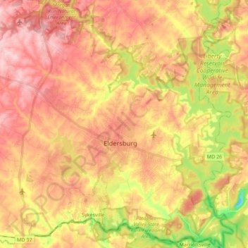
Name: Eldersburg topographic map, elevation, terrain.
Location: Eldersburg, Carroll County, Maryland, United States (39.34836 -77.01923 39.47911 -76.87324)
Average elevation: 167 m
Minimum elevation: 37 m
Maximum elevation: 256 m
Thank you for supporting this site ❤️
Make a donation
Make a donation
Other topographic maps
Click on a map to view its topography, its elevation and its terrain.