
Thank you for supporting this site ❤️
Make a donation
Make a donation
Fond du Lac topographic map
Click on the map to display elevation.
Thank you for supporting this site ❤️
Make a donation
Make a donation
About this map
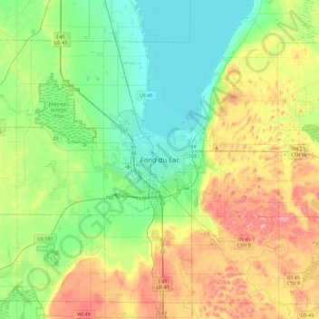
Name: Fond du Lac topographic map, elevation, terrain.
Location: Fond du Lac, Fond du Lac County, Wisconsin, United States (43.61488 -88.60580 43.93488 -88.28580)
Average elevation: 279 m
Minimum elevation: 224 m
Maximum elevation: 387 m
Thank you for supporting this site ❤️
Make a donation
Make a donation
Other topographic maps
Click on a map to view its topography, its elevation and its terrain.
Thank you for supporting this site ❤️
Make a donation
Make a donation
Thank you for supporting this site ❤️
Make a donation
Make a donation
Thank you for supporting this site ❤️
Make a donation
Make a donation