
Thank you for supporting this site ❤️
Make a donation
Make a donation
Paderne topographic map
Click on the map to display elevation.
Thank you for supporting this site ❤️
Make a donation
Make a donation
About this map
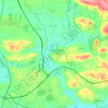
Name: Paderne topographic map, elevation, terrain.
Location: Paderne, Albufeira, Faro, 8200-495, Portugal (37.12790 -8.24864 37.21723 -8.15467)
Average elevation: 106 m
Minimum elevation: 25 m
Maximum elevation: 282 m
Thank you for supporting this site ❤️
Make a donation
Make a donation
Other topographic maps
Click on a map to view its topography, its elevation and its terrain.