
Make a donation
Herlong topographic map
Click on the map to display elevation.
Make a donation
Herlong
Herlong is a census-designated place in Lassen County, California. Herlong is located at the extreme eastern edge of the Sierra Nevada Mountain Range in the southeastern region of Honey Lake Valley, 8 miles (13 km) north of Doyle, at an elevation of 4,114 feet (1,254 m). Its population is 237 as of the 2020 census, down from 298 from the 2010 census. Herlong is located in southern Lassen County near the southeast edge of Honey Lake, about 70 miles (110 km) north of Reno, Nevada, and about 45 miles (72 km) south of Susanville, the county seat. The community is accessible to U.S. Route 395 via Lassen County Route A25 or Lassen County Route A26.
Make a donation
About this map
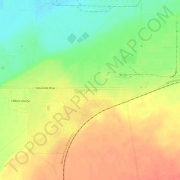
Name: Herlong topographic map, elevation, terrain.
Location: Herlong, Lassen County, California, 96113, United States (40.12351 -120.15465 40.16351 -120.11465)
Average elevation: 1,250 m
Minimum elevation: 1,221 m
Maximum elevation: 1,274 m
Make a donation
Other topographic maps
Click on a map to view its topography, its elevation and its terrain.
Susanville
United States > California > Lassen County
Susanville (formerly known as Rooptown) is a town in and is the county seat of Lassen County, California, United States. Susanville is located on the Susan River in the southern part of the county, at an elevation of 4,186 feet (1,276 m). Its population is 16,728 as of the 2020 census, down from 17,947 from…
Average elevation: 1,345 m
Westwood
United States > California > Lassen County
Westwood is a census-designated place (CDP) in Lassen County, California, United States. Westwood is located 20 miles (32 km) west-southwest of Susanville, at an elevation of 5,128 feet (1,563 m). Its population is 1,541 as of the 2020 census, down from 1,647 from the 2010 census..
Average elevation: 1,577 m
Make a donation