
Thank you for supporting this site ❤️
Make a donation
Make a donation
Stuttgart topographic map
Click on the map to display elevation.
Thank you for supporting this site ❤️
Make a donation
Make a donation
Stuttgart
Stuttgart covers an area of 207.35 km2 (80 sq mi) and sits at elevation ranging from 207 m (679 ft) above sea level by the Neckar river to 549 m (1,801 ft) on Bernhartshöhe hill – something rather unique in large German cities. The most prominent elevated locales in Stuttgart are the Birkenkopf (511 m (1,677 ft)) on the edge of the Stuttgart basin, the Württemberg (411 m (1,348 ft)) rising above the Neckar valley, and the Grüner Heiner (395 m (1,296 ft)) at the northeast end of the city.
Thank you for supporting this site ❤️
Make a donation
Make a donation
About this map
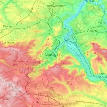
Name: Stuttgart topographic map, elevation, terrain.
Location: Stuttgart, Baden-Württemberg, Germany (48.69202 9.03860 48.86640 9.31602)
Average elevation: 351 m
Minimum elevation: 206 m
Maximum elevation: 534 m
Thank you for supporting this site ❤️
Make a donation
Make a donation