Geolocate

Região do Alentejo topographic map

Interactive map

Click on the map to display elevation.

About this map

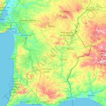
Name: Região do Alentejo topographic map, elevation, terrain.

Location: Região do Alentejo, Beja, 7800-561, Portugal (37.05510 -8.86058 39.05510 -6.86058)

Average elevation: 170 m

Minimum elevation: -3 m

Maximum elevation: 867 m

Other topographic maps

Click on a map to view its topography, its elevation and its terrain.

Guizo

Portugal > Beja > Beja

Guizo, Beja, 7800-661, Portugal

Average elevation: 116 m

Santa Vitória

Portugal > Beja > Beja

Santa Vitória, Beja, 7800-732, Portugal

Average elevation: 150 m

Beja

Portugal > Beja > Beja

Beja, Salvador e Santa Maria da Feira, Beja, 7800-427, Portugal

Average elevation: 166 m

Beringel

Portugal > Beja > Beja

Beringel, Beja, Portugal

Average elevation: 183 m

Mombeja

Portugal > Beja > Beja

Mombeja, Beja, 7800-641, Portugal

Average elevation: 188 m

São Matias

Portugal > Beja > Beja

São Matias, Beja, 7800-751, Portugal

Average elevation: 170 m

São Brissos

Portugal > Beja > Beja

São Brissos, Beja, 7800-741, Portugal

Average elevation: 188 m