
Make a donation
Lalitpur topographic map
Click on the map to display elevation.
Make a donation
Lalitpur
Lalitpur Metropolitan City (Nepali: ललितपुर महानगरपालिका, Lālitapura Mahānagarapālikā), also known as Patan (Sanskrit: पाटन, Pāṭana), Yala (Newar: 𑐫𑐮), and Manigal, is a metropolitan city and fourth most populous city of Nepal with 299,843 inhabitants living in 49,044 households per the 2021 census. It is located in the south-central part of Kathmandu Valley, a large valley in the high plateaus in central Nepal, at an altitude of 1,400 metres (4,600 feet).
Make a donation
About this map
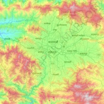
Name: Lalitpur topographic map, elevation, terrain.
Average elevation: 1,608 m
Minimum elevation: 819 m
Maximum elevation: 2,802 m
Make a donation
Other topographic maps
Click on a map to view its topography, its elevation and its terrain.
Kathmandu Valley
Nepal > Bagamati Province > Lalitpur
Kathmandu Valley is bowl-shaped. Its central lower part stands at 1,425 metres (4,675 ft). Kathmandu Valley is surrounded by five mountain ranges: Shivapuri hills (at an elevation of 2,732 metres (8,963 ft)), Phulchowki (2,762 metres or 9,062 feet), Nagarjun (2,128 metres or 6,982 feet), Champadevi (2,278…
Average elevation: 1,595 m
Make a donation