
Thank you for supporting this site ❤️
Make a donation
Make a donation
Chillihuani topographic map
Click on the map to display elevation.
Thank you for supporting this site ❤️
Make a donation
Make a donation
About this map
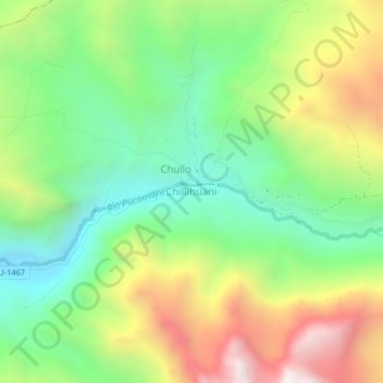
Name: Chillihuani topographic map, elevation, terrain.
Location: Chillihuani, Cusipata, Quispicanchi, Cusco, Perú (-13.88600 -71.44039 -13.84600 -71.40039)
Average elevation: 4,226 m
Minimum elevation: 3,743 m
Maximum elevation: 4,966 m
Thank you for supporting this site ❤️
Make a donation
Make a donation
Other topographic maps
Click on a map to view its topography, its elevation and its terrain.