
Thank you for supporting this site ❤️
Make a donation
Make a donation
Säffle kommun topographic map
Click on the map to display elevation.
Thank you for supporting this site ❤️
Make a donation
Make a donation
About this map
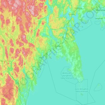
Name: Säffle kommun topographic map, elevation, terrain.
Location: Säffle kommun, Värmland County, Sweden (58.72533 12.41507 59.44795 13.58883)
Average elevation: 89 m
Minimum elevation: 40 m
Maximum elevation: 304 m
Thank you for supporting this site ❤️
Make a donation
Make a donation
Other topographic maps
Click on a map to view its topography, its elevation and its terrain.