
Make a donation
Cofton Hackett CP topographic map
Click on the map to display elevation.
Make a donation
About this map
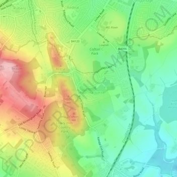
Name: Cofton Hackett CP topographic map, elevation, terrain.
Average elevation: 200 m
Minimum elevation: 130 m
Maximum elevation: 298 m
Make a donation
Other topographic maps
Click on a map to view its topography, its elevation and its terrain.
Lickey Hills Country Park
United Kingdom > England > Worcestershire > Bromsgrove > Cofton Hackett CP
Average elevation: 209 m
Make a donation
Make a donation
The Toposcope
United Kingdom > England > Worcestershire > Bromsgrove > Rubery
Average elevation: 226 m
Tanner's Green
United Kingdom > England > Worcestershire > Bromsgrove > Wythall CP
Average elevation: 158 m
Beacon Wood
United Kingdom > England > Worcestershire > Bromsgrove > Lydiate Ash
Average elevation: 210 m
Major's Green
United Kingdom > England > Worcestershire > Bromsgrove > Wythall CP
Average elevation: 146 m
Make a donation
Make a donation
Marlbrook
United Kingdom > England > Worcestershire > Bromsgrove > Lydiate Ash
Average elevation: 177 m
Make a donation