
Make a donation
Edlibach topographic map
Click on the map to display elevation.
Make a donation
About this map
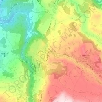
Name: Edlibach topographic map, elevation, terrain.
Location: Edlibach, Menzingen, Zug, 6313, Switzerland (47.16227 8.55148 47.20227 8.59148)
Average elevation: 693 m
Minimum elevation: 463 m
Maximum elevation: 921 m
Make a donation
Other topographic maps
Click on a map to view its topography, its elevation and its terrain.
Menzingen
The municipality is located on a moraine plateau between the Lorze and Sihl rivers at an elevation of about 800 m (2,600 ft). In 1848 the municipality of Neuheim separated from Menzingen. It consists of the village of Menzingen and a number of hamlets and individual farm houses.
Average elevation: 740 m
Oberägeri
The municipality is located in the eastern pre-alpine, high valley on the northern shores of the Ägerisee at an elevation of about 724 m (2,375 ft). It consists of the village of Oberägeri and the hamlets of Morgarten/Hauptsee and Alosen (at an elevation of 897 m (2,943 ft)) as well as scattered farm houses.
Average elevation: 912 m
Make a donation