
Make a donation
Reading topographic map
Click on the map to display elevation.
Make a donation
Reading
Jane Austen attended Reading Ladies Boarding School, based in the Abbey Gateway, in 1784–1786. Mary Russell Mitford lived in Reading for a number of years and then spent the rest of her life just outside the town at Three Mile Cross and Swallowfield. The fictional Belford Regis of her eponymous novel, first published in 1835, is largely based on Reading. Described with topographical accuracy, it is still possible to follow the steps of the novel's characters in present-day Reading. Reading also appears in the works of Thomas Hardy where it is called 'Aldbrickham'. It features most heavily in his final novel, Jude the Obscure, as the temporary home of Jude Fawley and Sue Bridehead.
Make a donation
About this map
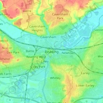
Name: Reading topographic map, elevation, terrain.
Location: Reading, England, RG1 1JL, United Kingdom (51.41642 -1.01007 51.49642 -0.93007)
Average elevation: 56 m
Minimum elevation: 32 m
Maximum elevation: 108 m
Make a donation
Other topographic maps
Click on a map to view its topography, its elevation and its terrain.
Berkshire
United Kingdom > England > Reading
All of the county is drained by the Thames. Berkshire divides into two topological (and associated geological) sections: east and west of Reading. North-east Berkshire has the low calciferous (limestone) m-shaped bends of the Thames south of which is a broader, clayey, gravelly former watery plain or belt from…
Average elevation: 100 m
Make a donation