
Thank you for supporting this site ❤️
Make a donation
Make a donation
Arbutus topographic map
Click on the map to display elevation.
Thank you for supporting this site ❤️
Make a donation
Make a donation
About this map
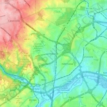
Name: Arbutus topographic map, elevation, terrain.
Location: Arbutus, Baltimore County, Maryland, 21227, United States (39.20743 -76.73361 39.28743 -76.65361)
Average elevation: 57 m
Minimum elevation: 0 m
Maximum elevation: 163 m
Thank you for supporting this site ❤️
Make a donation
Make a donation
Other topographic maps
Click on a map to view its topography, its elevation and its terrain.
Bowleys Quarters
United States > Maryland > Baltimore County > Bowleys Quarters
Average elevation: 2 m
Thank you for supporting this site ❤️
Make a donation
Make a donation
Soldiers Delight Natural Environment Area
United States > Maryland > Baltimore County > Owings Mills
Average elevation: 187 m
Thank you for supporting this site ❤️
Make a donation
Make a donation
Thank you for supporting this site ❤️
Make a donation
Make a donation