
Make a donation
Arnprior topographic map
Click on the map to display elevation.
Make a donation
Arnprior
Arnprior is located on the Trans-Canada Highway system, where Highway 417 to the east becomes the two-lane Highway 17 to the west. The town is served by the Arnprior Airport, elevation 108 m (355 ft), and the nearby Arnprior Water Aerodrome, elevation 100 m (330 ft), for general aviation; although there is no longer commercial aviation at the airport.
Make a donation
About this map
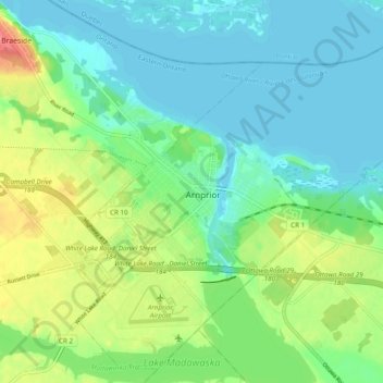
Name: Arnprior topographic map, elevation, terrain.
Location: Arnprior, Renfrew County, Eastern Ontario, Ontario, Canada (45.40219 -76.38726 45.46592 -76.28975)
Average elevation: 93 m
Minimum elevation: 74 m
Maximum elevation: 136 m
Make a donation
Other topographic maps
Click on a map to view its topography, its elevation and its terrain.
Make a donation
Foymount
Canada > Ontario > Renfrew County > Bonnechere Valley
The location is also popular for amateur astronomers given the high altitude and low levels of artificial light.
Average elevation: 432 m
Make a donation
Palmer Rapids
Canada > Ontario > Renfrew County > Brudenell, Lyndoch and Raglan
Average elevation: 319 m
Bonnechere
Canada > Ontario > Renfrew County > Killaloe, Hagarty and Richards
Average elevation: 174 m
Make a donation
Make a donation
Madawaska River
Canada > Ontario > Renfrew County > Greater Madawaska > Calabogie
Average elevation: 160 m
Make a donation
Lorwall Lake
Canada > Ontario > Renfrew County > Brudenell, Lyndoch and Raglan
Average elevation: 401 m
Make a donation
Make a donation
Make a donation
Make a donation
Make a donation
Make a donation
Mount St. Patrick Mountains
Canada > Ontario > Renfrew County > Greater Madawaska
Average elevation: 390 m
Madawaska Highlands
Canada > Ontario > Renfrew County > Killaloe, Hagarty and Richards
Average elevation: 272 m
Make a donation
Make a donation
Make a donation