
Make a donation
Farellones topographic map
Click on the map to display elevation.
Make a donation
Farellones
Located in the commune of Lo Barnechea, 36 km from Santiago at an altitude of 2,340 meters above sea level (7,874 feet), Farellones has a health centre, a school, and about 200 houses. The houses and cabins are made of wood, giving the village its characteristic look.
Make a donation
About this map
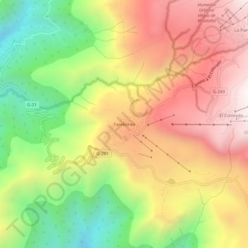
Name: Farellones topographic map, elevation, terrain.
Average elevation: 2,243 m
Minimum elevation: 1,611 m
Maximum elevation: 2,835 m
Make a donation
Other topographic maps
Click on a map to view its topography, its elevation and its terrain.
Santiago
Chile > Santiago Metropolitan Region > Provincia de Santiago
The city lies in the center of the Santiago Basin, a large bowl-shaped valley consisting of broad and fertile lands surrounded by mountains. The city has a varying elevation, gradually increasing from 400 m (1,312 ft) in the western areas to more than 700 m (2,297 ft) in the eastern areas. Santiago's…
Average elevation: 553 m
Make a donation
Santiago
Chile > Santiago Metropolitan Region > Provincia de Santiago
The city lies in the center of the Santiago Basin, a large bowl-shaped valley consisting of broad and fertile lands surrounded by mountains. The city has a varying elevation, gradually increasing from 400 m (1,312 ft) in the western areas to more than 700 m (2,297 ft) in the eastern areas. Santiago's…
Average elevation: 553 m
Make a donation
Recoleta
Chile > Santiago Metropolitan Region > Provincia de Santiago > Santiago
Average elevation: 556 m
Make a donation
Parque Quinta Normal
Chile > Santiago Metropolitan Region > Provincia de Santiago > Santiago
Average elevation: 526 m
Lo Barnechea
Chile > Santiago Metropolitan Region > Provincia de Santiago
Its pre-Hispanic inhabitants were called huaicoches (in Mapudungún: waykoche 'people who live in a landslide zone') because of the huaicos or huaycos of the region (in Quechua: wayqu 'stream'). Also called lloclla (in Quechua: lluqlla 'alluvium'), these are violent alluvial floods in which a large amount of…
Average elevation: 2,383 m
Make a donation
La Reina
Chile > Santiago Metropolitan Region > Provincia de Santiago > Santiago
Average elevation: 773 m
Make a donation
Peñalolén
Chile > Santiago Metropolitan Region > Provincia de Santiago > Santiago
Average elevation: 965 m
La Pintana
Chile > Santiago Metropolitan Region > Provincia de Santiago > La Pintana
Average elevation: 625 m
Pedro Aguirre Cerda
Chile > Santiago Metropolitan Region > Provincia de Santiago
Average elevation: 529 m
Make a donation