
Thank you for supporting this site ❤️
Make a donation
Make a donation
Argomulyo topographic map
Click on the map to display elevation.
Thank you for supporting this site ❤️
Make a donation
Make a donation
About this map
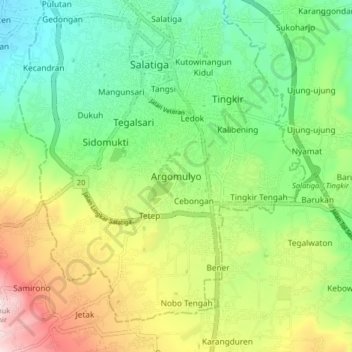
Name: Argomulyo topographic map, elevation, terrain.
Location: Argomulyo, Salatiga, Central Java, Java, 50731, Indonesia (-7.39569 110.46566 -7.31569 110.54566)
Average elevation: 675 m
Minimum elevation: 475 m
Maximum elevation: 1,025 m
Thank you for supporting this site ❤️
Make a donation
Make a donation
Other topographic maps
Click on a map to view its topography, its elevation and its terrain.
Gantangan Burung Bung Karno Dukuh Salatiga
Indonesia > Central Java > Salatiga > Dukuh > Glogolan
Average elevation: 599 m