
Thank you for supporting this site ❤️
Make a donation
Make a donation
Kademangan topographic map
Click on the map to display elevation.
Thank you for supporting this site ❤️
Make a donation
Make a donation
About this map
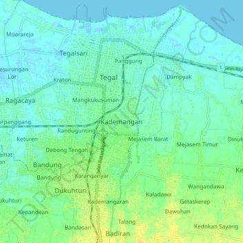
Name: Kademangan topographic map, elevation, terrain.
Location: Kademangan, Tegal, Central Java, Java, 52124, Indonesia (-6.92197 109.10211 -6.84197 109.18211)
Average elevation: 7 m
Minimum elevation: -3 m
Maximum elevation: 21 m
Thank you for supporting this site ❤️
Make a donation
Make a donation