
Thank you for supporting this site ❤️
Make a donation
Make a donation
Stuttgart-Nord topographic map
Click on the map to display elevation.
Thank you for supporting this site ❤️
Make a donation
Make a donation
About this map
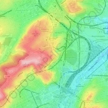
Name: Stuttgart-Nord topographic map, elevation, terrain.
Location: Stuttgart-Nord, Stuttgart, Baden-Württemberg, Deutschland (48.78302 9.14627 48.81059 9.20404)
Average elevation: 298 m
Minimum elevation: 222 m
Maximum elevation: 407 m
Thank you for supporting this site ❤️
Make a donation
Make a donation
Other topographic maps
Click on a map to view its topography, its elevation and its terrain.