
Make a donation
Bukit Panjang topographic map
Click on the map to display elevation.
Make a donation
Bukit Panjang
Bukit Panjang (/ˈbʊkɪt ˌpɑːndʒɑːŋ/ BUUK-it PAHN-jahng) is a planning area and residential town located in the West Region of Singapore. A portion of this town is situated on a low-lying elongated hill. The planning area is bounded by Bukit Batok to the west, Choa Chu Kang to the northwest, Sungei Kadut to the north, the Central Water Catchment to the east, and Bukit Timah to the south. Bukit Panjang New Town is located at the northern portion of the planning area. Bukit Panjang has an average elevation of 36m/118 ft.
Make a donation
About this map
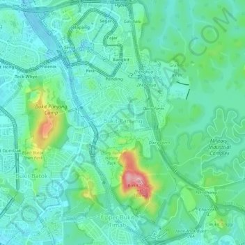
Name: Bukit Panjang topographic map, elevation, terrain.
Location: Bukit Panjang, West Region, Singapore (1.34186 103.75513 1.39081 103.79166)
Average elevation: 44 m
Minimum elevation: 8 m
Maximum elevation: 168 m
Make a donation
Other topographic maps
Click on a map to view its topography, its elevation and its terrain.
Fort Canning Park
The hill has a long history intertwined with that of the country due to its location as the highest elevation within walking distance to the city's civic district, within the Downtown Core. It is also a popular location for exhibitions, concerts, and outdoor recreation.
Average elevation: 19 m
Make a donation
Make a donation
Make a donation
Make a donation
Make a donation
Make a donation
Make a donation
Make a donation
Make a donation
Make a donation
Make a donation
Make a donation
Make a donation
Make a donation
Make a donation