
Singu Township topographic map
Interactive map
Click on the map to display elevation.
About this map
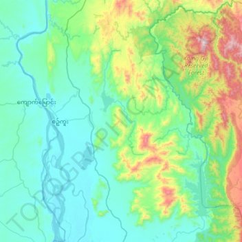
Name: Singu Township topographic map, elevation, terrain.
Location: Singu Township, Pyin Oo Lwin District, Mandalay, Myanmar (22.29482 95.90011 22.80648 96.33590)
Average elevation: 294 m
Minimum elevation: 63 m
Maximum elevation: 1,339 m
Other topographic maps
Click on a map to view its topography, its elevation and its terrain.
Myingyan Township
Myingyan Township, Myingyan District, Mandalay, 05251, Myanmar
Average elevation: 107 m