
Make a donation
Ocean Pines topographic map
Click on the map to display elevation.
Make a donation
About this map
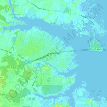
Name: Ocean Pines topographic map, elevation, terrain.
Average elevation: 3 m
Minimum elevation: -4 m
Maximum elevation: 17 m
Make a donation
Other topographic maps
Click on a map to view its topography, its elevation and its terrain.
Assateague State Park
United States > Maryland > Worcester County > Berlin > Golf Club Shores
Average elevation: 1 m
Assateague Island National Seashore
United States > Maryland > Worcester County > West Ocean City
Average elevation: 2 m
Snow Hill
United States > Maryland > Worcester County
Snow Hill was founded in 1686 in Somerset County by English settlers, who may have named it after a street and neighborhood of the City of London called "Snow Hill", despite the location's elevation of just 16 feet (4.9 m) above sea level and the infrequency of snowfall. The town received its first charter on…
Average elevation: 7 m
Make a donation