
Thank you for supporting this site ❤️
Make a donation
Make a donation
Waling topographic map
Click on the map to display elevation.
Thank you for supporting this site ❤️
Make a donation
Make a donation
About this map
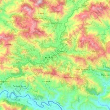
Name: Waling topographic map, elevation, terrain.
Location: Waling, Syangja, Gandaki Pradesh, Nepal (27.92016 83.66343 28.05044 83.86701)
Average elevation: 956 m
Minimum elevation: 339 m
Maximum elevation: 1,908 m
Thank you for supporting this site ❤️
Make a donation
Make a donation
Other topographic maps
Click on a map to view its topography, its elevation and its terrain.