
Thank you for supporting this site ❤️
Make a donation
Make a donation
Metsovo topographic map
Click on the map to display elevation.
Thank you for supporting this site ❤️
Make a donation
Make a donation
About this map
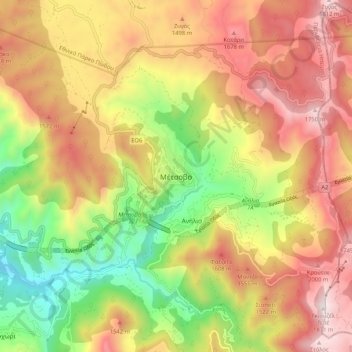
Name: Metsovo topographic map, elevation, terrain.
Average elevation: 1,318 m
Minimum elevation: 734 m
Maximum elevation: 1,863 m
Thank you for supporting this site ❤️
Make a donation
Make a donation
Other topographic maps
Click on a map to view its topography, its elevation and its terrain.
Vikos–Aoos National Park
Greece > Epirus > Ioannina Regional Unit
The Vikos–Aoös National Park (Greek: Εθνικός Δρυμός Βίκου–Αώου, romanized: Ethnikós Drymós Víkou–Aóou) is a national park in the region of Epirus in northwestern Greece. The park, founded in 1973, is one of ten national parks in mainland Greece and is located 30 kilometres (19…
Average elevation: 1,147 m