
Thank you for supporting this site ❤️
Make a donation
Make a donation
High Pike topographic map
Click on the map to display elevation.
Thank you for supporting this site ❤️
Make a donation
Make a donation
About this map
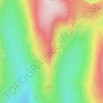
Name: High Pike topographic map, elevation, terrain.
Average elevation: 456 m
Minimum elevation: 208 m
Maximum elevation: 775 m
Thank you for supporting this site ❤️
Make a donation
Make a donation
Other topographic maps
Click on a map to view its topography, its elevation and its terrain.
Barrow
Vereinigtes Königreich > England > Westmorland and Furness > Barrow-in-Furness
Average elevation: 13 m
Appleby-in-Westmorland
Vereinigtes Königreich > England > Westmorland and Furness
Average elevation: 155 m