
Thank you for supporting this site ❤️
Make a donation
Make a donation
Dubois County topographic map
Click on the map to display elevation.
Thank you for supporting this site ❤️
Make a donation
Make a donation
About this map
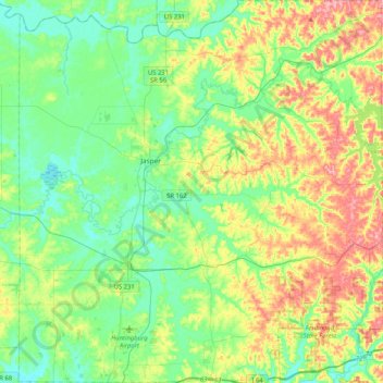
Name: Dubois County topographic map, elevation, terrain.
Location: Dubois County, Indiana, United States (38.20292 -87.07316 38.52652 -86.67989)
Average elevation: 163 m
Minimum elevation: 126 m
Maximum elevation: 241 m
Thank you for supporting this site ❤️
Make a donation
Make a donation
Other topographic maps
Click on a map to view its topography, its elevation and its terrain.