
Thank you for supporting this site ❤️
Make a donation
Make a donation
Gohar topographic map
Click on the map to display elevation.
Thank you for supporting this site ❤️
Make a donation
Make a donation
About this map
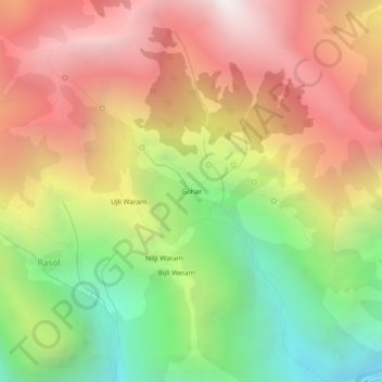
Name: Gohar topographic map, elevation, terrain.
Location: Gohar, Bhuntar, Kullu, Himachal Pradesh, India (32.01907 77.28972 32.05907 77.32972)
Average elevation: 2,853 m
Minimum elevation: 1,598 m
Maximum elevation: 4,054 m
Thank you for supporting this site ❤️
Make a donation
Make a donation