
Tumbler Ridge topographic map
Click on the map to display elevation.
About this map
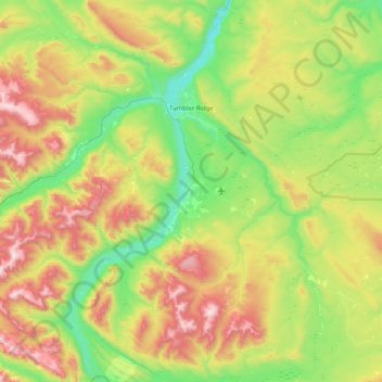
Name: Tumbler Ridge topographic map, elevation, terrain.
Average elevation: 1,153 m
Minimum elevation: 698 m
Maximum elevation: 2,059 m
Other topographic maps
Click on a map to view its topography, its elevation and its terrain.
Van Somer Point
Canada > British Columbia > Peace River Regional District > Area B (Finlay Valley/Beatton Valley)
Average elevation: 670 m
Black Bear Ridge
Canada > British Columbia > Peace River Regional District > Area B (Finlay Valley/Beatton Valley)
Average elevation: 1,314 m
Tsay Keh Dene Nation
Canada > British Columbia > Peace River Regional District > Area B (Finlay Valley/Beatton Valley)
Average elevation: 688 m
Mount Hermann
Canada > British Columbia > Peace River Regional District > Tumbler Ridge
Average elevation: 1,439 m
Carbon Peak
Canada > British Columbia > Peace River Regional District > Area E (Moberly Lake/Sukunka Valley)
Average elevation: 1,421 m
Dawson Creek
Canada > British Columbia > Peace River Regional District > Dawson Creek
Average elevation: 739 m
Reef Canyon
Canada > British Columbia > Peace River Regional District > Area B (Finlay Valley/Beatton Valley)
Average elevation: 1,107 m