
Thank you for supporting this site ❤️
Make a donation
Make a donation
Straßdorf topographic map
Click on the map to display elevation.
Thank you for supporting this site ❤️
Make a donation
Make a donation
About this map
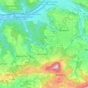
Name: Straßdorf topographic map, elevation, terrain.
Average elevation: 424 m
Minimum elevation: 298 m
Maximum elevation: 707 m
Thank you for supporting this site ❤️
Make a donation
Make a donation
Other topographic maps
Click on a map to view its topography, its elevation and its terrain.
Kleinishof
Deutschland > Baden-Württemberg > Ostalbkreis > Schwäbisch Gmünd > Metlangen
Average elevation: 470 m
Hetzenbühlhof
Deutschland > Baden-Württemberg > Ostalbkreis > Schwäbisch Gmünd > Oberbettringen
Average elevation: 412 m
Thank you for supporting this site ❤️
Make a donation
Make a donation
Kleindeinbach
Deutschland > Baden-Württemberg > Ostalbkreis > Schwäbisch Gmünd
Average elevation: 378 m
Siechenberg
Deutschland > Baden-Württemberg > Ostalbkreis > Schwäbisch Gmünd > Straßdorf
Average elevation: 377 m
Großdeinbach
Deutschland > Baden-Württemberg > Ostalbkreis > Schwäbisch Gmünd
Average elevation: 407 m
Thank you for supporting this site ❤️
Make a donation
Make a donation