
Thank you for supporting this site ❤️
Make a donation
Make a donation
Southside topographic map
Click on the map to display elevation.
Thank you for supporting this site ❤️
Make a donation
Make a donation
Southside
The elevation of Southside is 354 feet (108 m).
Thank you for supporting this site ❤️
Make a donation
Make a donation
About this map
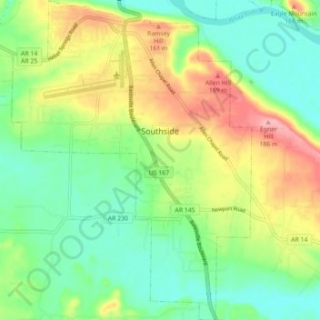
Name: Southside topographic map, elevation, terrain.
Location: Southside, Independence County, Arkansas, United States (35.67332 -91.67008 35.74472 -91.60392)
Average elevation: 112 m
Minimum elevation: 65 m
Maximum elevation: 190 m
Thank you for supporting this site ❤️
Make a donation
Make a donation
Other topographic maps
Click on a map to view its topography, its elevation and its terrain.
Thank you for supporting this site ❤️
Make a donation
Make a donation
Thank you for supporting this site ❤️
Make a donation
Make a donation
Thank you for supporting this site ❤️
Make a donation
Make a donation
Bryant Woodland Heights
United States > Arkansas > Independence County > Batesville
Average elevation: 107 m
Thank you for supporting this site ❤️
Make a donation
Make a donation
Quail Valley
United States > Arkansas > Independence County > Batesville > Quail Valley
Average elevation: 110 m
Thank you for supporting this site ❤️
Make a donation
Make a donation