
Galgenen topographic map
Interactive map
Click on the map to display elevation.
About this map
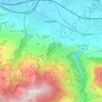
Name: Galgenen topographic map, elevation, terrain.
Location: Galgenen, March, Schwyz, 8854, Schweiz (47.14382 8.84684 47.19155 8.89957)
Average elevation: 681 m
Minimum elevation: 406 m
Maximum elevation: 1,275 m
Other topographic maps
Click on a map to view its topography, its elevation and its terrain.
Rosen
Schweiz > Schwyz > March > Reichenburg
Rosen, Reichenburg, March, Schwyz, 8864, Schweiz
Average elevation: 545 m
Sattelegg
Schweiz > Schwyz > March > Vorderthal
Sattelegg, Vorderthal, March, Schwyz, 8857, Schweiz
Average elevation: 1,179 m
Rinderweidhoren
Schweiz > Schwyz > March > Altendorf
Rinderweidhoren, Altendorf, March, Schwyz, 8846, Schweiz
Average elevation: 1,155 m