
Thank you for supporting this site ❤️
Make a donation
Make a donation
Tamun topographic map
Click on the map to display elevation.
Thank you for supporting this site ❤️
Make a donation
Make a donation
About this map
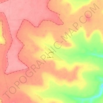
Name: Tamun topographic map, elevation, terrain.
Location: Tamun, Al Talh District, Shabwah Governorate, Yemen (15.18285 47.47551 15.22285 47.51551)
Average elevation: 1,493 m
Minimum elevation: 1,421 m
Maximum elevation: 1,521 m
Thank you for supporting this site ❤️
Make a donation
Make a donation
Other topographic maps
Click on a map to view its topography, its elevation and its terrain.